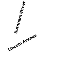
19 BURNHAM ST
Owner Information
RUSZKOWSKI DENISE S
19 BURNHAM ST
HAVERHILL, MA 01830


Property Details
19 BURNHAM ST is classified as a Mixed Use (Primarily Residential, some Commercial) (Cape).
The primary structure on this property was built in 1948. There are 2,503ft2 of built area within this property. There is 2,503ft2 of residential/living space within this property. This property is listed as having 8 rooms.
19 BURNHAM ST is valued at $324,300. The land is valued at $146,000 and the structures are valued at $176,500. There is an additional valuation of $1,800 on this property.
The most recent deed for 19 BURNHAM ST is recorded at the local registrar in Book 31368, Page 468. 19 BURNHAM ST was last sold on Thursday, May 24, 2012 for $100.
Assessment data from fiscal year 2022.
Flood Data
This property is partially within the AE Zone (within floodplain). Approximately 0.02 acres (9.11%) of the property is within this zone.
This information is sourced from the FEMA National Flood Hazard Layer. See our full disclamer.
Broadband Internet Providers
| Provider | Type | Bandwidth (mbps) | |
|---|---|---|---|
| Verizon New England Inc. | DSL | 7 | 0 |
| VSAT Systems, LLC. | Satellite | 2 | 1 |
| HughesNet | Satellite | 25 | 3 |
| GCI Communication Corp. | Satellite | 0 | 0 |
| Comcast | Cable | 1000 | 35 |
| Viasat Inc | Satellite | 100 | 3 |
Broadband service provider data from December 2020.
Adjacent Properties
- 254 LINCOLN AVE
Single Family Residential owned by PARK JENNIFER-ETALI - 260 LINCOLN AVE
Single Family Residential owned by KUHN ELIZABETH J-ETAL - 15 BURNHAM ST
Single Family Residential owned by LITTLE SHAWN D ETUX - 264 LINCOLN AVE
Single Family Residential owned by PATRICIA ROWELL REALTY TRUST - 25 BURNHAM ST
Single Family Residential owned by LECOLST WILLIAM J